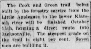
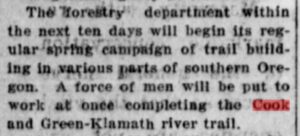
 

1957 bridge construction near the
Cook & Green/Middle Fork confluence.

Cook & Green Trail

There was no true “trail” along Cook & Green Creek until late 1915. Robert Cook and William A. Green were trappers with the Hudson’s Bay Company (HBC). Apparently Cook and Green followed tracks worn by wildlife and indigenous peoples from the Middle Fork of what would become known as Applegate Creek, scouting south over the Siskiyou Crest to Seiad Valley. A creek off the Middle Fork became known as Cook & Green, the name of the ranch they established on the Klamath River in the 1850s. Green was the postmaster when the Seiad post office was founded in 1858 and served until 1861.

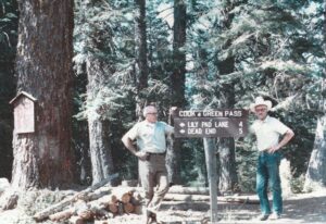
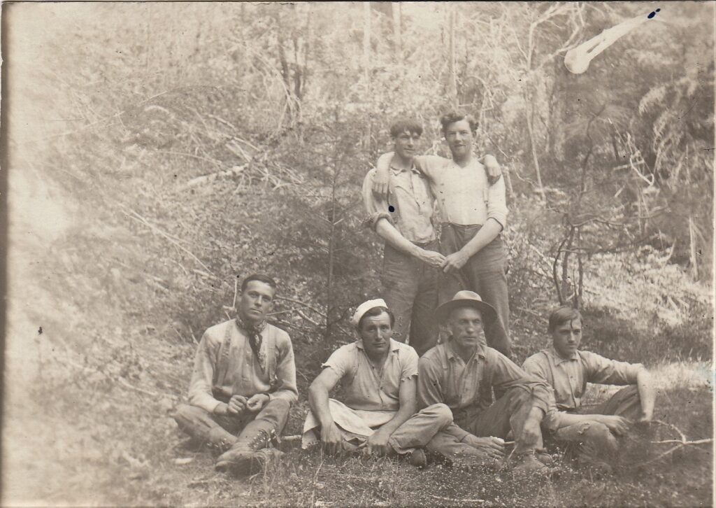
Lee Port Jr. and Morris Byrne near Cook & Green Pass

Over the years, three myths developed about the identities of Cook and Green. One is traced to Lee Port Sr. (1889-1956), the Applegate District Ranger for the Rogue River National Forest (and father of Lee Jr., shown in this 1970s photograph). Lee Sr. didn’t come to Oregon until around 1910. In 1945, after his retirement, he related some “Notes on Historical Events.” Of course, Lee Sr. was not a first-hand witness to most of these events; he was relaying rumors and lore, often with his own twist or misinterpretation. His Note regarding Cook & Green (reported and typed by an unknown intermediary) reads:

Could Lee Sr. have meant the HBC trappers and Seiad Valley settlers? If so, he didn’t disclose their full stories, and misplaced their activities in the 1870s.

The second mythological line emerged in U.S. Forest Service studies published more than three decades after Lee Port’s “Notes”:

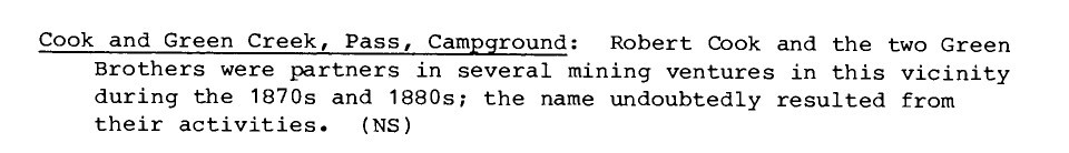
LaLande, Prehistory and history of the Rogue River National Forest: a cultural resource overview (1980).

From 1914 U.S. Geological Survey “Seiad” topo map.

LaLande, From Abbott Butte to Zimmerman Burn: A Place-Name History and Gazetteer of the Rogue River National Forest (2001). Correspondence with the author and exhaustive reviews of mining claims, tax and census records, and Oregon and California newspapers published 1850-1900 have provided no evidence of “two Green brothers” or such a partnership. But it is notable that the effort to name the nearby butte “Cook & Green” was not launched until 1981. Earlier maps by the U.S. Geological Survey show no name for this landmark.

The third myth comes from descendants of Robert Alexander Cook (1833-1919). He arrived in the Willamette Valley in 1853 but did not reach the Applegate area until 1859, when he settled to farm at Missouri Flat over 40 miles downstream of Cook & Green Creek. There is no record that this Robert Cook ever explored or prospected in the Siskiyous, but his grandson Robert Edwin Cook (1877-1975) did. Robert Edwin was interviewed in great detail over multiple days in 1975 by historian Kay Atwood. He described his years of traveling and mining along the Klamath River, and how he would need to take a stagecoach from Jacksonville through Yreka. He never alluded to what would have been a much shorter route established by his grandfather, had it existed. Notably, Cook family members have no information as to the identity of “Green.”

It is easy to see how “Cook & Green” the HBC trappers morphed into the legend of Robert Alexander Cook. He, like William A. Green, was a postmaster – but at Foots Creek, and not until 1886. His sons did do some prospecting to the south of “home base,” but only as far south as Beaver Creek – in 1875, for cinnabar aka mercury. That is still 20 miles downstream from Cook & Green Creek. Robert Alexander served as a Jackson County Commissioner for a couple of terms. Instead of taking his mules and wagon over the 22 miles of roads from Foots Creek to Jacksonville for meetings, he found it easier to hike six miles on a primitive trail. Thus his descendants’ veneration of his trailblazing, although misplaced in location and time.

Middle Fork trail crew. Seated L-R: David Dorn (1878-1956), “Frenchie,” Bill Fruit (1872-1951), Ernest Dorn (1893-1982). Standing L-R: Ervin Lewis (1887-1952), Floyd McKee (1891-1975).]  A new crew, again led by Bill Fruit, started work on the Cook & Green Trail in 1912.

Small placer mining operations speckled the Siskiyous from 1853, and invasive hydraulic mining followed in the 1870s, but the more significant hard-rock mines and their associated camps didn’t arise until the turn of the century. A continuous wagon road from the Applegate Valley to the Blue Ledge Mine was completed in 1906. Those on the southern side of the Siskiyou Crest were now clamoring for a road or at least a decent trail to access the booming camp. “The only way to get to Yreka from the Blue Ledge district is by way of Medford.” The Siskiyou News, October 25, 1906.

But then Crater National Forest was established in 1908, and the federal government soon began surveying and building proper trails in the Upper Applegate watershed. First, around 1909, a trail up the Middle Fork to provide a camp at the confluence with Cook & Green Creek.

The Crater Ranger, November 12, 1912.  The Medford Mail Tribune reported the imminent completion of the trail on August 18, 1914, but unfortunately the newspaper was wrong:

The work continued into 1915:

Medford Mail Tribune, April 17, 1915.

During the Great Depression, in 1936-37, the Civilian Conservation Corps “brush rangers” did some modest trail maintenance and built a campground with three rock stoves and six tables. But the basic trail we enjoy today is the enduring work of Bill Fruit and his crews in 1912-15. Yes, Fruit Mountain four miles to the west of the Trail is named after Bill Fruit.


Did the Forest Service and CCC build these trails and campground on public land owned by the U.S. Government? South of the campground an 80-acre block of private land was clear cut in the 1950s. The Bureau of Land Management (BLM) resurveyed the area when this property changed hands in 1975 and initially believed there was a major error in the original survey — that the block was well to the northwest and straddled the campground, a piece of Cook & Greek Trail, and significant lengths of Butte Fork and Horse Camp Trails. The new owners, Pete Munday of Medford and William Keen of Murphy, moved aggressively to log this untouched forest. Based on the Red Buttes Wilderness Council’s opposition to the campground logging, Dolores Lisman (for many years and still a MBHS member and Director) challenged the state and federal agencies that were about to acknowledge the change of ownership and permit devastating logging based on the preliminary, unofficial survey. BLM and the Forest Service looked again. Indeed, that resurvey was way out of whack. The final survey moved the 80-acres back to its original north-south position, with the campground solidly back in public hands.

Despite the success of this community effort to save the campground, it was eventually abandoned by the Forest Service.

Take a hike on the Cook & Green Trail 108 years after its creation! Envision HBC trappers Robert Cook and William Green bushwhacking their way, and thank the early Forest Service crews who built this wide accommodating trail. Here are more resources about the Cook & Green Trail:


Cook and Green Butte Trail: 4 Reviews, Map – California | AllTrails

Rogue River-Siskiyou National Forest – Cook and Green Trail #959 (usda.gov)

Cook and Green Trail #959 Hiking Trail, Happy Camp, California (hikingproject.com)